વાવાઝોડું 2025: અરબીસમુદ્રમાં બનતી સિસ્ટમના રૂટનું અનુમાન અગાઉથી લગાવી શકાતું નથી તે આજે ફરી સાબિત થઈ ગયું છે. અરબી સમુદ્રમાં લો પ્રેશર બન્યું હોવા છતાં પણ હજુ આગળ શું થાય તેનું કંઈ નક્કી નથી.
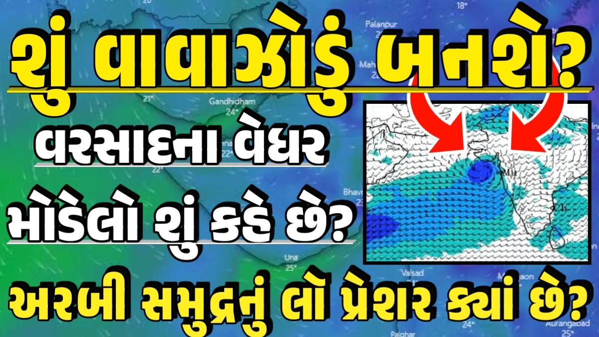
હલમાં જે લો પ્રેશર બન્યું છે તે ગોવાથી ઉપર કોંકણના કાંઠે અરબીસમુદ્રમાં બનેલું છે. અત્યારે આ લો પ્રેશર મહારાષ્ટ્રના કાંઠા નજીક બનેલું છે જ્યાં આ સિસ્ટમને મજબૂત બનવા માટે સમુદ્રનું વાતાવરણ જોઈએ તેટલું અનુકૂળ ન હોવાથી સિસ્ટમ મજબૂત બનવામાં સમય લેશે અને ક્રમશ ઉત્તર તરફ એટલે કે ગુજરાત તરફ આગળ વધશે.

બીજું કે જો આ સિસ્ટમ હાલના રુટ અનુસાર વધુ ને વધુ ગુજરાત નજીક આવતી જાય તો ફરી તેને ખુલ્લો સમુદ્ર મળવાનો બંધ થઈ જાય એટલે ફરી તેને મજબૂત બનવા માટે અવરોધ આવી શકે છે.
અત્યારે મહારાષ્ટ્રના કાંઠે રહેલ આ સિસ્ટમને ખુલ્લા અરબી સમુદ્રમાં જવા માટે થોડુ પશ્ચિમ તરફ જવું પડે, પરંતુ ઓમાન તરફથી આવતા પવનો તેને તે બાજુ જવા દેતા નથી અને સિસ્ટમને મહારાષ્ટ્રના કાંઠા સાઈડ ધકાવીને રાખે છે. હાલ આ સિસ્ટમ ધીમે ધીમે ઉત્તર તરફ એટલે કે ગુજરાત બાજુ આગળ ગતિ કરી રહી છે.
આવી વધારે માહિતી મેળવવા માટે અહીં ક્લિક કરો.
વાવાઝોડું 2025: આ સિસ્ટમના લીધે ઘણા મોડલો પણ ગોટે ચડેલ છે. અમુક મોડલને એમ બતાવી રહ્યા છે કે આ સિસ્ટમ થોડી જોર કરી ખુલ્લા અરબી સમુદ્ર બાજુ જઈને મજબૂત બની ફરી ગુજરાત તરફ આવતા આવતા નબળી પડી જશે. તો અમુક મોડલ એમ પણ બતાવી રહ્યાં છે કે, આ સિસ્ટમ ખુલ્લા અરબી સમુદ્ર સુધી નહિ પહોંચી શકે એટલે કે વાવઝોડા કેટેગરી સુધી પહોંચે તે પહેલાં જ નબળી પડી ગુજરાત આસપાસ આવી જશે.
આમ, અલગ અલગ મોડેલો આ સિસ્ટમનો અલગ અલ્ગ રૂટ બતાવી રહ્યા છે. લો પ્રેશર બની ગયુ છતાં સિસ્ટમ વાવાઝોડા કેટેગરી સુધી પહોંચશે કે નહીં તે અને તેનો રૂટ પણ ક્લિયર થતો નથી. આ તમામ પરિબળો ધ્યાનમાં રાખીએ તો, સિસ્ટમને વાવાઝોડા સુધી મજબૂત બનવું થોડુ અઘરું લાગી રહ્યું છે.
આ લો પ્રેશર સિસ્ટમને ડિપ્રેશનથી ડીપડિપ્રેશન સુધી મજબૂત બનવાની સંભાવના સારી છે, માત્ર વધુ મજબૂત બનીને વાવાઝોડા કેટેગરી સુધી જાય તે બાબતે હજુ સ્પષ્ટતા નથી.
It has been proven again today that the route of the system forming in the Arabian Sea cannot be predicted in advance. Even though low pressure has formed in the Arabian Sea, nothing is certain about what will happen next.
The low pressure that has formed in Hull is formed in the Arabian Sea on the Konkan coast above Goa. At present, this low pressure has formed near the coast of Maharashtra, where the sea environment is not as conducive as it should be for this system to strengthen, so the system will take time to strengthen and will gradually move towards the north, i.e. towards Gujarat.
આવી વધારે માહિતી મેળવવા માટે અહીં ક્લિક કરો.
વાવાઝોડું 2025: Secondly, if this system keeps coming closer and closer to Gujarat according to the current route, it may again stop getting open sea, which may hinder it from strengthening again.
Currently, this system, which is on the coast of Maharashtra, has to move a little towards the west to go to the open Arabian Sea, but the winds coming from Oman do not allow it to go in that direction and keep the system pushed towards the coast of Maharashtra. At present, this system is slowly moving towards the north, i.e. towards Gujarat.
Many models have also been put on hold due to this system. Some models are showing that this system will strengthen a little towards the open Arabian Sea and then weaken as it approaches Gujarat.
Some models are also showing that this system will not reach the open Arabian Sea, that is, it will weaken and come around Gujarat before reaching the cyclone category.
Thus, different models are showing different routes of this system. Even though low pressure has formed, it is not clear whether the system will reach the cyclone category or not and its route is also not clear. Considering all these factors, it is looking a little difficult for the system to strengthen to a cyclone.
There is a good chance that this low pressure system will strengthen from a depression to a deep depression, but it is not yet clear whether it will strengthen further and reach the cyclone category.